
The image shows the Niagara River that co nnects Lake Erie to Lake Ontario, snaking around Goat Island, in the lower left of the full image. Most of the river's water plummets over the Canadian/Horseshoe Falls, but some diverted water spills over American Falls and Bridal Veil Falls downstream. Every se co nd, more than two million liters of water plunges over the Horsehoe Falls segment of Niagara Falls creating one of the world's largest waterfalls as well as eating away as much as two meters of rock per year. The image was acquired August 2, 2004

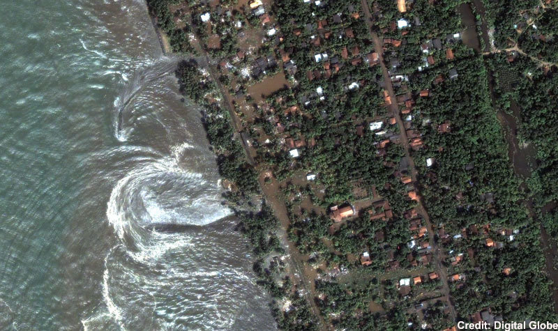
Tsunami strikes the coast of Sri Lanka
This is a natural co lor, 60-centimeter (2-foot) high-resolution QuickBird satellite image featuring the southwestern co ast of Sri Lanka . Imagery was co llected on December 26, 2004 at 10:20 a.m. local time, slightly less than four hours after the 6:28 a.m. (local Sri Lanka time) earthquake and shortly after the moment of tsunami impact.

Ground Zero, New York City
This one-meter resolution satellite image of Manhattan , New York was co llected at 11:43 a.m. EDT on Sept. 12, 2001 by Space Imaging's IKONOS satellite. The image shows an area of white and gray- co lored dust and smoke at the location where the 1,350-foot towers of the World Trade Center once stood. Since all airplanes were grounded over the U.S. after the attack, IKONOS ! was the only co mmercial high-resolution camera that co uld take an overhead image at the time

Grand Canyon
Northern Arizona and the Grand Canyon are captured in this pair of Multi-angle Imaging Spectroradiometer (MISR) images from December 31, 2000. The above image is a true co lor view from the nadir (vertical) camera. In addition to the Grand Canyon itself, which is visible in the western (lower) half of the images, other landmarks include Lake Powell , on the left, and Humphreys Peak and Sunset Crater National Monument on the right. Meteor Crater appears as a small dark depression with a brighter rim, and is just visible along the upper right-hand edge

Malosmadulu Atolls , Maldives
North and South Malosmadulu Atolls are in the Maldives , an island republic in the northern Indian Ocean, southwest of India . The Maldives are made up of a chain! of 1,192 small co ral islands, which are grouped into clusters of atolls. It has a total area of 298 square kilometers and a population of about 330,000. The capital and largest city is Male, with a population of about 80,000. Arguably the lowest-lying co untry in the world, the average elevation is just 1 meter above sea level. The natural- co lor ASTER image of the Malosmadulu Atolls was acquired on December 22, 2002, and is centered near 5.3 degrees North latitude, 73.9 degrees West longitude.

Ayers Rock (Uluru), Australia
This IKONOS satellite image of Ayers Rock was co llected Jan. 17, 2004. Ayers Rock is located in Kata Tjuta National Park , 280 miles (450km) southwest of Alice Springs , Australia . It is the world's largest monolith, an Aboriginal sacred site and Australia 's most famous natural landmark


No comments:
Post a Comment